This is an introductory series of videos that establishes the context of the CFedS Program. Topics covered include a brief history of surveying as it relates to the U.S., cultural awareness…
The CFedS Program consists of the following seven courses which take approximately 20 weeks to complete.
Course 2: Boundary Law & Title Examination
This course discusses several basic land law principles and the analysis of legal descriptions contained in deeds and other official documents that transfer interests in land…
Course 3: Survey Evidence Analysis
This set of videos and other teaching aids addresses one of the most complex tasks in cadastral surveying, the analysis of the field evidence and its correlation with the written record.
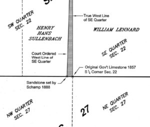
Course 4: Restoration of Lost Corners
This course consists of four videos, some reading, and three exercises, on the “Restoration of Lost Corners”. The legal, mathematical, and practical applications of the methods of…

Course 5: Introduction to Water Boundaries
This course consists of an interactive course on the basics of water boundaries. It is not intended to make one an expert, but rather, to raise awareness of riparian issues…
Course 6: Subdivision of Sections
This course focuses on the subdivision of sections. It addresses subdivision of normal sections, lotted closing sections, elongated and fractional sections, as well as the unique method known as…
Course 7: Federal Boundary Standards & Business Practices
The final course offered in the initial CFedS Training Program is about the Federal Boundary Standards and business practices. It offers foundational explanation of the…